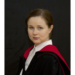
Dr. Ekaterina Sklyar
Abschluss: PhD, Cambridge University
Schwerzenbach, Schweiz
Werdegang
Berufserfahrung von Ekaterina Sklyar
2 Jahre und 5 Monate, Okt. 2008 - Feb. 2011
PhD Student Collaborator on the PPS Arctic Project (project work)
University of Cambridge, Scott Polar Research Institute
Contributed remote sensing analysis for understanding the position and structure of the northern treeline within the PPS Arctic Project, Norway, and the joined Norwegian/Russian project BENEFITS.
2001 - 2011
Fieldwork organiser and remote sensing analyst
University of Cambridge, Scott Polar Research Institute
Performed interpretation of Landsat images in the field, collected ground and literature data for a supervised classification of images over the areas of heavy reindeer grazing in Norway; validation of unsupervised classification results with “ground truth”; field assessment of the developed remote sensing analysis approach and field validation of land-cover maps for the areas under human impact.
2 Jahre und 3 Monate, Mai 2005 - Juli 2007
Junior Research Engineer
Moscow State University, Faculty of Geography
Performed environmental assessment of the effect of air and water pollution from the copper-nickel smelters on the components of ecosystems using satellite images; created environmental and vegetation maps of areas around Moncherorsk and Nikel in the Kola peninsula (Russia).
2006 - 2007
Junior Manager and Teacher of the Field School
Moscow State University, Faculty of Geography
“Remote Sensing for Ecosystems Assessment” in Kola Peninsula, Russia. Helped in establishing the school, translated learning material from English into Russian and helped writing parts of the course material on GIS, composed school brochures and designed its logo. Lectured on GIS and Remote Sensing and marked students’ final reports.
2002 - 2007
Remote sensing analyst and head of student expedition
Moscow Sate University, Faculty of Geography
Organised and led the student field trips to Kola peninsular and Komi, Russia, collecting field data (geobotanical observations, field sampling, land-use) for the interpretation of satellite images.
2003 - 2005
Remote Sensing Analysts (project work)
Moscow State University, Faculty of Geography
Co-developed the methodology for remote sensing assessment of vegetation in the Lake Imandra basin, performed computer and field interpretation of Landsat 7 ETM+ images using collected field data and constructed digital vegetation maps within the project of the American Association for the Advancement of Science and Russian Academy of Sciences “The Kola Peninsula: Applications of Interactive Integrated Assessment and Modelling to Design Sustainable Development Strategies for Arctic Watersheds”.
2002 - 2002
Member of a joint expedition to Abisko, Sweden
Moscow State University, Faculty of Geography
Performed geobotanical observations and phytomass calculations within the joined expedition of Cambridge University and the Moscow State University.
Ausbildung von Ekaterina Sklyar
5 Jahre und 1 Monat, Okt. 2008 - Okt. 2013
Geography, Environmental Monitoring&Assessment, Remote Sensing, GIS
Cambridge University
Scott Polar Research Institute (SPRI), Trinity College; PhD dissertation title: "Remote sensing methods for environmental monitoring of human impact on sub-Arctic ecosystems in Europe"
1 Jahr und 1 Monat, Okt. 2007 - Okt. 2008
GIS&Remote Sensing, Environmental Impact Assessment
University of Cambridge
Department of Geography, Trinity College; MPhil in GIS&Remote Sensing (Honours); Master dissertation title "Spatial variation in land cover change using multi-temporal satellite images of the Kola peninsula, Russia"
2 Jahre und 1 Monat, Juli 2003 - Juli 2005
Geography
Moscow State University
Department of Environmental Management, Faculty of Geography MSc in Geography (Honours); Master dissertation title: "Remote sensing methods for mapping state of ecosystems in the Imandra lake basin)"
4 Jahre und 1 Monat, Juli 1999 - Juli 2003
Ecology, Geography
Moscow State University
Department of Environmental Management, Faculty of Geography; BSc in Ecology and Environmental Management; BSc dissertation title: "Studies of industrial impact on vegetation in the Monchegorsk region using Landsat images"
Sprachen
Englisch
Fließend
Russisch
Muttersprache
